Kanlaon Volcano Erupts Again — Third Time This Year, PHIVOLCS Releases Ash Dispersion Maps
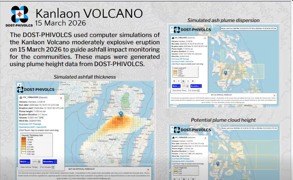
Kanlaon Volcano on Negros Island erupted for the third time this year on Sunday evening, March 15, generating a massive five-kilometer eruption column. The Philippine Institute of Volcanology and Seismology (PHIVOLCS) logged the moderately explosive eruption at around 6:07 p.m.
PHIVOLCS immediately released computer simulations of the ash dispersion using the Ash3D model, designed to help volcanologists and local government units monitor ashfall impact. The agency posted the simulation maps on its Facebook page to guide communities in affected areas.
According to PHIVOLCS, the eruption column is drifting to the southeast and northeast. The agency said the maps showing ashfall density, distribution, dispersal patterns, and plume height can be used to identify and verify areas currently affected or potentially at risk of ashfall.
This is the third moderately explosive eruption for Kanlaon in 2026 alone. The volcano also erupted on February 19 and February 26, with the second eruption causing significant ashfall in nearby communities. Alert Level 2 remains raised over the volcano.
PHIVOLCS is strictly prohibiting entry into Kanlaon's four-kilometer radius permanent danger zone (PDZ). Residents in surrounding areas are advised to remain vigilant and prepare for possible ashfall, especially those downwind of the eruption column.
Source: GMA News